Drvenik – Plišivac tradiční cache – GC29ZXX
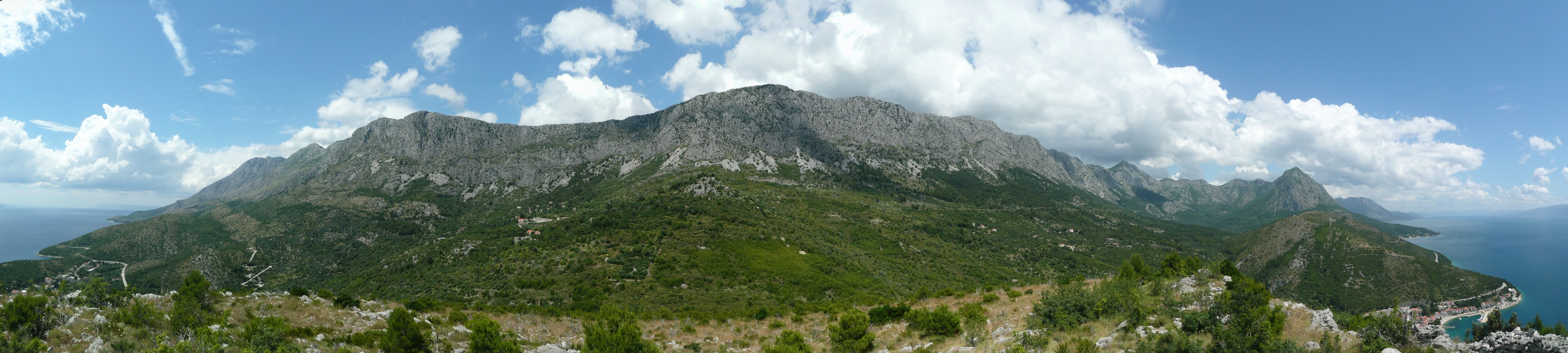
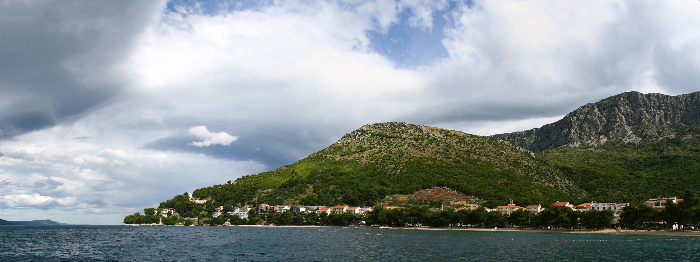
EN: The three parts of Drvenik from Plišivac summit.HR: Brdo Plišivac leži između tri dijela Drvenika.
CS: Vrchol Plišivac mezi třemi částmi Drveniku.
ENGLISH
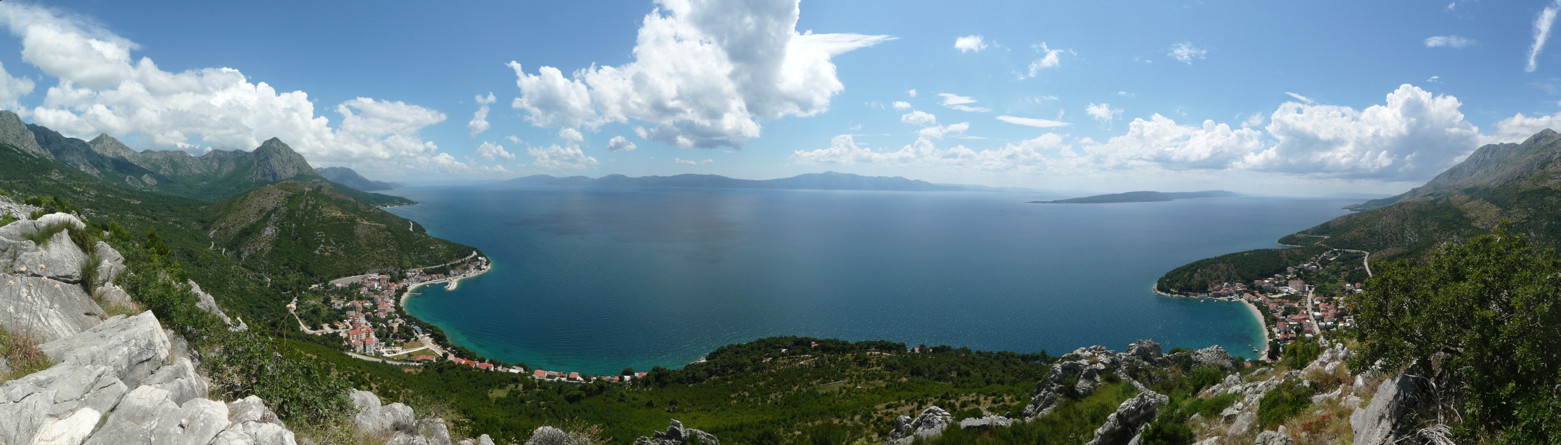
Drvenik is well known seaside resort on the Makarska Riviera. The coastal village is located in two bays denominated Donja Vala (Lower Bay) and Gornja Vala (Upper Bay), which are separated by a massif of hill Plišivac. Although most tourists considered Drvenik as a pair of bays with hotels and beaches, this is not the whole Drvenik.
The third part, Gornji Drvenik (Upper Drvenik), today called Selo, is located under the cliff between the peaks of Sokolic (788 m) and Krive Toke (739 m) in Rilič mountains. A long history of Drvenik is presented by an originally gothic, later in baroque style rebuilt church of St. George from 15th century. Another landmark is a ruin of Gradina, a defence fortress from 17th century - a time of Turkish occupation.
While on the coast, the inhabitants lived on fishing, maritime transport, crafts, and later tourism, under the mountains people were farming for their livelihood. It has been like this for centuries and with the advent of the 20th century it did not change so much. A quiet life not only in Gornji Drvenik, but also in other villages in the surrounding foothills, finished 7th January 1962, when an earthquake destroyed or severely damaged most of the houses. Year 1962 became a turning point in the life of the Makarska Riviera, because during the next two years the majority of the population from foothill villages including Gornji Drvenik moved into villages on the coast.
Plišivac
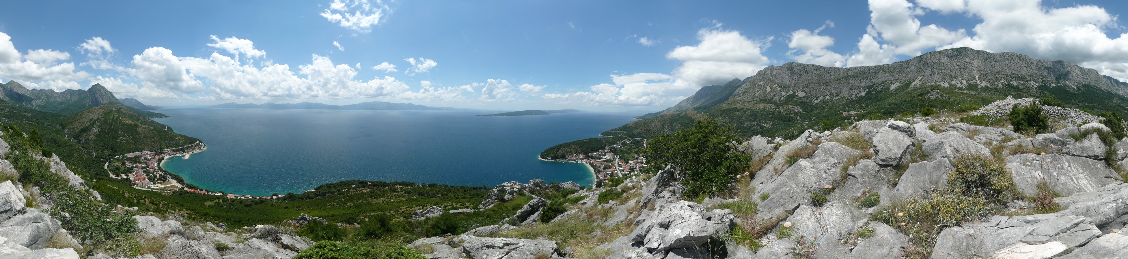
This cache will take you up to the Plišivac summit, which lies approximately halfway among the three parts of Drvenik. You will climb to the altitude of 241 meters that will allow you the view of Gornji Drvenik (Selo), of Gradina and two bays of today's seaside resort at the same time. Of course you can see the Adriatic Sea with the island of Hvar and the Peljesac peninsula. On the other side you will be able to see the monumental south cliff of Rilič Mountains.
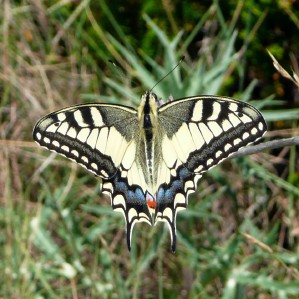
| Papilio machaon Old World Swallowtail Lastin rep Otakárek fenyklový |
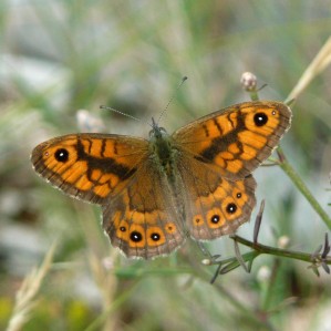
Lasiommata megera Wall Brown Zidni okaš Okáč zední |
 |
 |
 |
 |
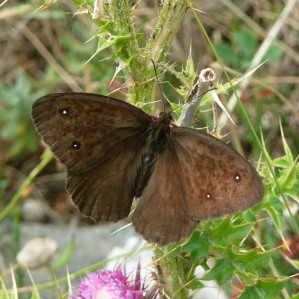
| Minois dryas The Dryad Modrooki okaš Okáč ovsový |
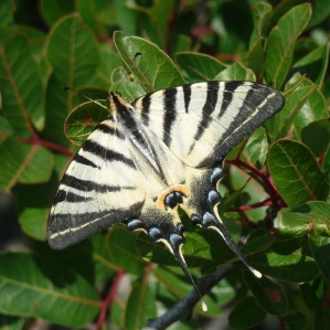
Iphiclides podalirius Scarce Swallowtail Prugasto jedarce Otakárek ovocný |
On the rocky and stony summit of Plišivac, which is constantly exposed to the sun's rays, are predominant grasses and flowers, while shrubs and trees are sporadic. For favourable conditions the summit became a home to many butterflies. Sometimes, apart from them you can see lizards and snakes that hide quickly among the rocks.
Ways to the cache
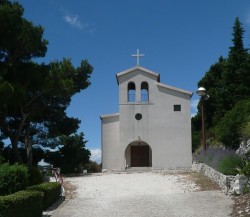
The first option is the route from the church of Our Lady of Caramel. Following this route, you will climb honestly most of the target altitude. From the Adriatic Highway you will turn off at waypoint 1T to the church, under which you can park your car (waypoint 1P). A foundation stone of this church was laid in 1965 and the church was completed two years later, church services are currently held on Sundays.
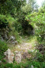
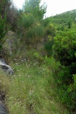
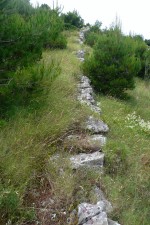
From the church you will go on a wide path to the north-east up to a hill. This path leads to the local BTS, where you will walk to the starting point of the old trail (waypoint 1C). The trail is not maintained regularly, in many places you will walk through tall grass or interlace between bushes, but the trail is passable. Walk along the path to the waypoint SU, from where a path marked with stripes on the rocks leads to the summit.
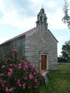
Another option is a path from the church of St. George, which can be reached by a small road. You will turn on the Adriatic Highway in Donja Vala (waypoint 2T). You will go up along the road through serpentines to the church at which you can conveniently park your car (waypoint 2P). Not far from the church is located a crossroad of road and race route (waypoint 2C) leading to a group of old houses. Follow this path until you reach a group of houses, where you will find a small grey pointer (waypoint 2D) opposite the reconstructed house. Behind him starts an old trail leading to Plišivac and a new church. This old trail is not also maintained but is passable. The path will lead you along the western slopes of Gradina and Plišivac to the waypoint SU, where the path turns off to the summit.
No matter what path you choose, you should equip with solid shoes, long trousers and at least 1.5 litres of water. Because parts of the trail as well as the summit are exposed to sunlight and it can be hard to find shade a hat can be also useful.
We would like to thank to David Melichar and Eva Haunerova for their help with preparing this cache ;-)
CZECH
Celý text je k dispozici včetně diakritiky.
Drvenik je známé přímořské letovisko na Makarské riviéře. Pobřežní osada se rozkládá ve dvou zátokách Donja Vala (Dolní zátoka) a Gornja Vala (Horní zátoka), které jsou od sebe odděleny masivem vrchu Plišivac. Ač takto zná Drvenik většina turistů, dvojice pláží s hotely není celý Drvenik.
Pod stěnou mezi vrcholy Sokolic (788 m) a Krive Toke (739 m) pohoří Rilič leží třetí část, Gornji Drvenik, dnes označovaný jako Selo. Dlouhou historii Drveniku zde dokládá původně gotický, později barokně upravený kostel sv. Jiří z 15. století, nebo zřícenina protiturecké pevnosti Gradina ze 17. století.
Zatímco na pobřeží se obyvatelé živili rybářstvím, námořní dopravou, řemesly a později turistikou, pod horami bylo obživou zemědělství. Příliš se nezměnilo ani s příchodem 20. století. Poklidný život obyvatel nejen Gornji Drveniku, ale i dalších podhorských vesnic v okolí, skončil 7. ledna 1962, kdy zemětřesení zničilo či vážně poškodilo většinu horských domů. Rok 1962 se tak stal předělem ve způsobu života na Makarské riviéře, neboť během následujících dvou let se většina obyvatel podhorských vesnic včetně Drveniku přestěhovala do osad na pobřeží.
Plišivac
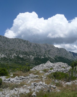
Keš vás zavede na vrchol Plišivac, který leží přibližně uprostřed mezi všemi třemi částmi Drveniku. Vystoupáte do nadmořské výšky 241 metrů, aby vám holý vrchol umožnil výhled na Gornji Drvenik (Selo) s Gradinou i obě zátoky dnešního letoviska. Samozřejmě uvidíte na Jadranské moře s ostrovem Hvar a poloostrovem Pelješac, na druhé straně si budete moci prohlédnout monumentální jižní stěnu pohoří Rilič.
Na skalnatém a kamenitém vrcholku Plišivace, vystaveném slunečním paprskům převažují traviny a květiny, zatímco keřů či stromů je na něm poskrovnu. Pro příhodné podmínky se vrchol stal domovem pro řadu motýlů. Kromě motýlů tu můžete občas zahlédnout ještěrky a hady, kterak se rychle schovávají mezi kameny.
Kudy ke krabičce
První možností je trasa od kostela Panny Marie Karmelské, po které poctivě vystoupáte většinu z cílové nadmořské výšky. Z Jadranské magistrály odbočíte na waypointu 1T ke kostelu, pod kterým můžete zaparkovat auto (waypoint 1P). Základní kámen tohoto kostela byl položen v roce 1965 a dokončen byl o dva roky později. V současnosti jsou v něm bohoslužby slouženy v neděli.
Od kostela se vydáte směrem na severovýchod po široké cestě do kopce. Ta vás zakrátko dovede k místní BTS, odkud dojdete ještě kousek na začátek staré stezky (waypoint 1C). Stezka nepatří mezi udržované trasy, na mnoha místech se budete prodírat vysokou trávou či proplétat mezi keříky, ale cesta je průchozí. Po stezce dojdete až k waypointu SU, odkud se jde mezi kameny na vrchol. Poslední úsek je vyznačen pruhy na kamenech.
 |
 |
 |
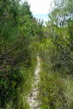 |
| Path to Plišivac takes many forms, sometimes it's hard to find a way itself... Cesta na Plišivac má mnoho podob, občas je těžké cestu vůbec najít... |
|||
Druhou možností je cesta od kostela svatého Jiří, kde vám auto může ušetřit část stoupání. Ke kostelu sv. Jiří se dostanete po malé silničce, na kterou odbočíte z Jadranské magistrály v Donje Vale (waypoint 2T). Po silničce vystoupáte serpentinami až ke kostelu, u něhož lze pohodlně zaparkovat (waypoint 2P). Kousek od kostela se od silničky odpojuje cesta (waypoint 2C) vedoucí ke skupině starých domů. Po této cestě dojdete až ke skupině domů, kde naleznete malý šedý ukazatel (waypointu 2D) naproti opravenému domu. Za ním začíná stará stezka vedoucí na Plišivac a dále k novému kostelu. Opět platí, že stará cesta není udržovaná, ale je průchozí. Cesta vás povede po západních svazích Gradiny a Plišivace až k waypointu SU, odkud vede cesta k vrcholu.
Na cestu se vybavte raději pevnou obuví, dlouhými kalhoty a alespoň 1,5 litrem tekutin na osobu. Část cesty včetně vrcholu je vystavena slunci a jen těžko se hledá stín, proto je vhodná i pokrývka hlavy.
Děkujeme Davidovi Melicharovi a Evě Haunerové za jejich pomoc při přípravě této cache ;-)
Zpět na listing na Geocaching.com / Back to cache page on Geocaching.com